Source-to-sink processes of fluvial sediments
in the South China Sea
随着中国的和平崛起和国际政治的风云变幻,南海在近年来日益成为国际上关注的焦点,捍卫我国在南海的合法权益成了中国目前政治、外交的重中之重。然而,目前我们对这片位于祖国南疆的蓝色国土的了解却实在是少得可怜,这极大地限制了我国在南海争取合法权益时的话语权。尽早在现有条件下最大程度地提升我们对南海的认识,成了每一个以海洋为研究对象的中国科学家无法推卸的责任。
十年磨一剑,我院刘志飞教授及其团队成员多年来踏遍了南海周边的每一寸土地,共采集了超过1500个沉积物样品,其中包括汇入南海的180多条河流的河流沉积物样品和南海海洋表层沉积物样品。通过对这些样品展开粘土矿物含量以及元素含量分析、结合现场锚系观测及沉积物柱状样样品分析,刘志飞教授团队在国际上首次系统地、全面地获得了南海周边河流对南海沉积物输入的贡献以及这些沉积物在输入南海后的扩散路径。研究发现,南海周边不同河流输入南海的沉积物在矿物和元素成分上具有很大的差异性,造成这种差异性的主要原因为不同物源区岩性、构造活动以及气候条件的不同。河流沉积物在南海中的扩散与海流的活动直接相关,发现在南海东北部海区底层海流是重要的沉积物搬运介质。同时,通过对晚第四纪以来南海北部、西部和南部沉积物样品的分析,发现三个海区各自具有不同的沉积物分布特征,且对应于不同的沉积物输运机制。
该研究成果正式发表于《Earth-Science Reviews》第153卷(2016年2月)。ESR为地球科学领域一区顶级杂志,影响因子为7.337。本文第一作者及通讯作者均为我院刘志飞教授。
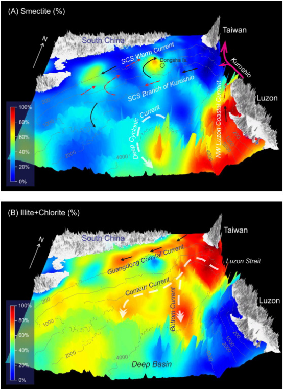
Fig. 13.Interpretation of spatial transport processes of the major clay mineral species in the northern SCS. (A) Smectite (%). (B) Illite + chlorite (%). The maps are created using the three-dimensional topography with overlays of clay mineral distribution (%). Isobath curves of 200, 1000, 2000, and 4000 m are indicated to show the seafloor configuration.
作者主页链接:
刘志飞:http://mlab.tongji.edu.cn/16/5f/c8723a71263/page.htm
Citation:
Liu Z, Zhao Y, Colin C, et al. Source-to-sink transport processes of fluvial sediments in the South China Sea[J]. Earth-Science Reviews, 2016, 153:238-273.
全文链接:http://dx.doi.org/10.1016/j.earscirev.2015.08.005
Abstract:
The South China Sea offers an excellent case for studying source-to-sink transport processes of fluvial sediments among the global marginal seas. This study synthesizes existing clay mineralogical and geochemical data from ~ 1500 samples from the seafloor and surrounding rivers, deepwater mooring observation results, and high-resolution glacial–cyclic clay mineralogy records from six high-quality sediment cores. Source-to-sink sediment transport from the river mouth to the continental shelf and then to the abyssal basin is investigated at two time scales: modern process and Late Quaternary glacial cycles. The results firstly show the high diversity of clay mineralogical and geochemical compositions in riverbed surface sediments surrounding the South China Sea, e.g., dominant illite and chlorite in Taiwan, overwhelming majority of smectite in Luzon, dominant kaolinite in South China, and similar amounts of the four clay mineral species in Red and Mekong river systems. The formation of these fluvial sediments through chemical weathering in surrounding drainage systems is controlled principally by the East Asian monsoon climate with warm temperature and high precipitation, and subordinately by tectonic activity and specific lithological character. The basin-wide distribution of clay mineral assemblages combined with neodymium and strontium isotopic compositions reflects strong provenance control and differential settling effects. The differential settling of kaolinite in slightly saline and proximal regions relative to smectite in more saline and distal regions is well demonstrated in the South China Sea. Through combining clay mineralogical distributions on the seafloor with observed oceanic current systems, the modern transport pathways can be well established, e.g., in the northern South China Sea, illite and chlorite from Taiwan are mainly carried by contour currents with the strong influence of mesoscale eddies.
High-resolution sediment dynamic analysis for the Late Quaternary reveals different sediment transport patterns in the northern, western, and southern South China Sea when the land–sea configuration dramatically changed during glacial conditions. In the north, the terrigenous dispersal is mainly controlled by provenance supply and oceanic current transport. In the west, the clay mineral assemblage reflects variations of the prevailing surface current influenced by monsoon winds. In the south, the clay mineral input indicates intensive chemical weathering during interglacial periods and strengthened physical erosion during glacial periods. The transport of terrigenous sediments since the last glaciation is quantitatively reconstructed through studying two deepwater sediment cores located in the northern South China Sea. The relative contributions from three provenances (South China, Luzon, and Taiwan) highlight their distinct variability over the last 28 ka, implying that the southward shift of the inter-tropical convergence zone (ITCZ) at 16 ka BP caused an increased sediment contribution from South China, the intensified influence of the Kuroshio Current intrusion controls more efficient westward transport of Luzon sediments, and the stronger deepwater current transports Taiwan-sourced sediments further westward from the last glaciation to the Holocene.