
Yunfei Du 1, Xiangju Han 1, Ya Ping Wang 2, Daidu Fan 1,*, Jicai Zhang 2,*
1 State Key Laboratory of Marine Geology, Tongji University, Shanghai 200092, China
2 State Key Laboratory of Estuarine and Coastal Research, East China Normal University, Shanghai 200241, China
* Corresponding author.
Email: ddfan@tongji.edu.cn,jicai_zhang@163.com.
Abstract
The suspended sediment front (SSF) in the Yangtze River Estuary significantly affects regional circulation, water quality, and productivity. However, the quantitative understanding of its multiscale spatio‐temporal variations and associated ecological effects remains largely limited. Utilizing suspended sediment concentration remote sensing data from 2012 to 2018, we applied an improved gradient-based front detection algorithm to identify SSFs. Our analysis highlighted significant variability in the SSF and established its oscillating boundaries. The mean longitude location of the front is approximately 122.2°E, extending up to 122.8°E, with its occurrence frequency negatively correlated with water depth. The control effect of estuarine engineering projects on lateral sediment exchange results in the more frequent occurrence of stable banded fronts in these areas. The SSF exhibits notable spatial pattern variability and fluctuations on tidal to interannual scales. Compared to other tidal types, the front extends furthest offshore during spring tides due to enhanced tidal mixing and seaward residual flow. The seasonal variations in the frontal location are closely related to ocean dynamic processes, jointly controlled by the mixed layer depth, wind speed, wind direction, wave intensity, and sea surface temperature. The direct influence of sediment load from the Yangtze River is most pronounced in July, coinciding with peak sediment load. The interannual variations indicate a strong correlation between frontal migration and sediment load. Meanwhile, extreme storm events cause significant resuspension of bed sediments, resulting in substantial offshore movement of the SSF (>14 km), with effects persisting for at least 2 days. Major floods modulate the short-term fluctuation range of the front by significantly increasing the sediment transport flux. Further investigation into the ecological effects of the SSF reveals that in summer, the dual front system comprising the SSF and plume front strongly controls estuarine primary productivity, with regions of high chlorophyll-a concentration aligning well with the seaward oscillation boundary of the SSF. Temperature, salinity, and nutrient concentration near the SSF also exhibit drastic changes. Conversely, in winter, insufficient runoff results in a single SSF system, leading to suboptimal nutrient, temperature, and light conditions, and consequently, very low primary productivity.
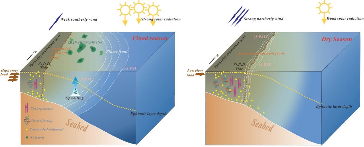
Figure. Conceptual diagram of the seasonal variation mechanism of SSF and its ecological effects in the YRE.
Full Article:https://doi.org/10.1016/j.watres.2025.123349
Frontiers in Marine Science:Linking interannual variability of turbidity fronts in the Eastern China Seas to local processes and ocean warming
Yunfei Du 1, Daidu Fan 1,*, Jicai Zhang 2
1 State Key Laboratory of Marine Geology, Tongji University, Shanghai, China
2 State Key Laboratory of Estuarine and Coastal Research, East China Normal University, Shanghai, China
* Corresponding author.
Email: ddfan@tongji.edu.cn.
Abstract
The turbidity front is susceptible to rapid changes in ocean hydrodynamics. Understanding its variability is crucial for elucidating material transport on continental shelves in light of evolving land-ocean interactions. However, the long-term frontal variability and its controlling mechanism over the shelf sea scale still need further study. Using a decade of satellite observations, this study assesses the interannual variability of turbidity fronts in the Eastern China Seas and their responses to local processes and rapid ocean warming. A gradient-based front detection algorithm and frontal probability are used to identify the geographical locations of turbidity fronts and their variability at the interannual scale, respectively. Regional heterogeneities in interannual variations and controlling mechanisms of frontal activity are observed. Specifically, the significant (p<0.05) and strongest correlations show that wind wave, horizontal temperature gradient, and mixed layer depth are identified as the most important drivers of interannual variations in frontal activity in the Bohai, Yellow, and East China Seas, respectively. The El Niño-Southern Oscillation influences frontal anomalies through a delayed wind-response mechanism (>=4 months). Notably, the recent increase in frontal probability (+0.07%/year) in offshore areas of the Yellow and East China Seas is primarily attributed to an intensified horizontal temperature (density) gradient (+0.0005 °C/km/year) resulting from ocean warming. As ocean warming continues, the offshore transport of terrigenous materials is expected to increase, potentially enhancing ocean primary productivity and carbon sequestration, and altering ecosystem function and fisheries.
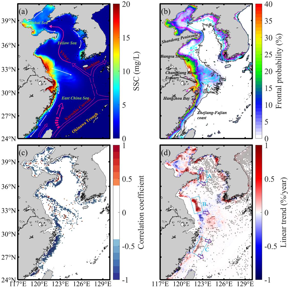
Figure . The spatial distribution of the 10-year mean SSC. The white and magenta arrows represent the coastal currents and the Yellow Sea Warm Current (YSWC) in winter, respectively. (B) The distribution pattern of the 10-year mean frontal probability. The magenta, cyan, and black lines represent 20-, 40-, and 60-m isobaths, respectively. (C) The spatial pattern of correlation coefficients between the 10-year mean frontal probability and water depth. (D) The spatial distribution of long-term trends in frontal probability. The blue boxes represent three typical areas with interannual enhancements of frontal probability, including the coast of Shandong Peninsula (Area A), the Jiangsu Shoal (Area B), and the Zhejiang-Fujian coast (Area C). From north to south, the five purple arrows depict the cross-shelf transport pathways as follows: from the shear zone of the Lubei Coastal Current and the YSWC to the Western North Yellow Sea Mud; from the Shandong Peninsula coastal currents to the Central Yellow Sea Mud; southeasterly transport to southwestern Cheju Island by the Subei coastal current; easterly transport in northern Zhe-Min; and easterly transport in northern Taiwan (Liu et al., 2023; Ren et al., 2015; Yuan et al., 2005). The black dots in (C, D) indicate statistically significant correlations (p<0.05).
Full Article:https://doi.org/10.3389/fmars.2025.1530555